
By Dan Mathers
Vermont’s five 4,000-foot peaks might get overshadowed by New York’s 46 or New Hampshire’s 48, but what the Green Mountain state lacks in quantity of big peaks it makes up for in quality.
Vermont’s highest summits reward hikers with fun and challenging climbs, rugged alpine ridges, and stunning views. All but one of the peaks is located on the Long Trail, and the only one not on the trail is easily reachable via a short spur trail, making it possible to bag all of Vermont’s 4,000-foot peaks in one multi-day backpacking trip.
Here’s a look at hiking Vermont’s highest peaks.

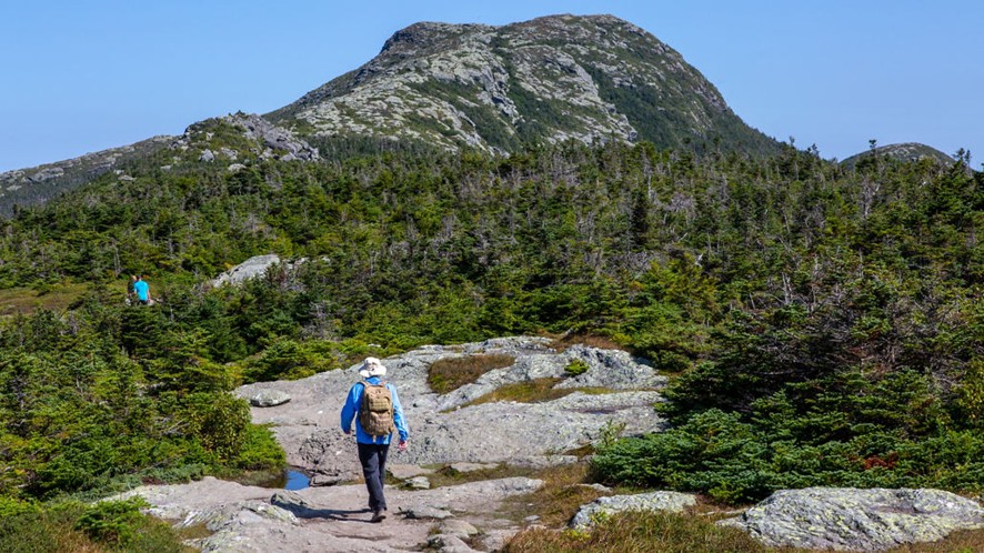
Mount Mansfield
Location: Underhill, Vermont
Elevation: 4,393 feet
Difficulty: Moderate to very difficult depending on route
Summit Views: Exceptional alpine and ridgeline views
Mount Mansfield is Vermont’s tallest peak, standing 4,393 feet. The peak can be crowded due to visitors arriving by auto road and gondola rides. But tolerating the crowds is worth it to enjoy the hike up the mountain and exceptional views from the summit.
Hiking the Long Trail 4.6 miles up and back is probably the most popular route on Mansfield. The Sunset Ridge Trail up the mountain is a Vermont classic, with exposed ledges and sweeping views. On a mountain of difficult, challenging trails, the rugged Hell Brook Trail is considered very difficult, featuring ladders and rock scrambling. It is not recommended in wet conditions and is not for beginners.
Killington Peak
Location: Mendon, Vermont
Elevation: 4,235 feet
Difficulty: Moderate
Summit Views: Very good
Vermont’s second-highest mountain is Killington Peak. It’s also one of the Northeast’s most accessible 4,000-footers, thanks in part to it being home to a popular ski resort of the same name. The summit features a fire tower that offers stunning views. While the Long Trail doesn’t pass over the summit, it comes close, and a short spur trail makes it easy to bag Killington.
The Bucklin Trail is the most popular hiking route up the mountain and is a little more than seven miles round trip. Thanks to the ski resort, the peak is also accessible via a gondola ride and short hike, making it easy to reach for beginner hikers and families with young kids.

Camel’s Hump
Location: Huntington, Vermont
Elevation: 4,083 feet
Difficulty: Moderate to difficult
Summit Views: Spectacular 360-degree views
The rocky, bald summit of Camel’s Hump is arguably the best peak in the Green Mountain state. Camel’s Hump is tied for the third-highest mountain in the state with Mount Ellen, standing at 4,083 feet.
The expansive views from its summit are incredible, with views of the Adirondacks to the west and White Mountains to the east.
Hikers can choose from three routes up the mountain. The Burrows Trail is the shortest, most direct climb. It is a 4.7-mile out-and-back hike to the summit and climbs more than 2,200 feet. The Camel’s Hump Trail is a 6-mile out-and-back with more than 2,500 feet of climbing. Hikers can also create a loop with the Forest City, Long, and Burrows trails for a roughly 6-mile hike with a little over 2,400 feet of climbing.

Mount Ellen
Location: Warren, Vermont
Elevation: 4,083 feet
Difficulty: Moderate
Summit Views: Limited at summit
Mount Ellen is the least heralded of Vermont’s 4,000-footers. While it is as tall as Camel’s Hump, it lacks in prominent features and summit views. In fact, its summit is wooded and offers only limited views. However, excellent views are found nearby at a ski lift close to the summit.
The Jerusalem Trail is the most popular route to Mount Ellen’s summit. The moderate route is a little more than six miles round trip. The Long Trail offers a more difficult, challenging route to the summit.
Mount Ellen is located close to the last mountain on this list, Mount Abraham, and many hikers look to bag both summits in a single day.

Mount Abraham
Location: Lincoln, Vermont
Elevation: 4,006 feet
Difficulty: Moderate
Summit Views: Outstanding alpine summit views
Mount Abraham just squeaks onto the list at 4,006 feet. But for hikers in the know, it’s a beloved summit. That’s because it rewards hikers with open ridgelines and outstanding alpine summit views for only modest effort.
The Battell Trail up Abraham is probably the most popular route up the peak. It features some steep sections, but nothing outrageous. The trip up and back is a little over five miles and has about 2,500 total feet of elevation gain. Hikers can also go up by way of Lincoln Gap for a shorter, easier route at just about five total miles, which makes it a good hike for beginner hikers starting to take on 4,000-footers.